Amazon forest: what it is and its characteristics
Amazon rainforest is the largest equatorial forest in the world and is invaluable
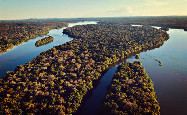
Juruena National Park. Adriano Gambarini image for WWF-Brasil
The Amazon forest is scientifically called equatorial broadleaved forest. It gets its name for presenting a vegetation with large and broad leaves; and for being close to the equator, being dense, perennial (does not lose its leaves throughout the year in any season) and hydrophilic (adapted to the presence of abundant water).
The Amazon forest covers 40% of the Brazilian territory, in addition to occupying portions of the territories of Venezuela, Colombia, Bolivia, Ecuador, Suriname, Guyana and French Guiana.
In Brazil, it occupies practically the entire northern region, mainly the states of Amazonas, Amapá, Pará, Acre, Roraima and Rondônia, in addition to northern Mato Grosso and western Maranhão.
The Amazon forest has a heterogeneous composition, with phytophysiognomies ((the first impression caused by the vegetation) that can be classified according to the proximity to water courses: igapó forests, floodplain forests and terra firme forests.
igapó forests

Edited image of Roldão Lima Junior is available on Wikipedia
The igapó forests are permanently flooded plains, with flooded soils. The main types of species found in this type of physiognomy are the water lily, açaí and the cane toad.
floodplain forests

Image of Nareeta Martin, is available on Unsplash
The floodplain forests, or floodplains, are lands that surround the rivers and that usually flood during the flood season. The species most present in this type of phytophysiognomy are cocoa, copaiba and rubber trees.
dry land forests

Rosina Kaiser image, available on Pixabay
The terra firme forests are vegetations that develop in higher regions, which do not flood throughout the year. In this phytophysiognomy are found large trees that can reach 50 meters in height. The crown of this type of vegetation is intertwined, making it difficult for sunlight to enter its interior, preventing the development of large amounts of low-lying plants.
In the terra firme Amazonian forest, the most common tree species are Brazil nut, mahogany and guaraná.
Due to its equatorial climate, the Amazon forest has high temperatures and air humidity, which range between 22 and 28 ºC and 80%, respectively. The pluviometric index (rain) is also high, varying between 1,400 and 3,500 mm per year.
The seasons of the year in the Amazon rainforest are distinguished by two periods: dry and rainy.
Despite harboring a great biodiversity of plants and animals, the Amazon forest has a soil considered poor, with a thin layer of nutrients. However, the humus formed by the decomposition of organic matter (leaves, flowers, animals and fruits) is rich in nutrients used in the growth of forest vegetation. To learn more about humus, take a look at the article: "Humus: what it is and what its functions are for the soil".
Amazon Biome
The Amazon biome, also called the Amazon ecological domain or the Amazon biogeographic domain, is the set of ecosystems interconnected by the Amazon forest, located in the Amazon Basin. It occupies Bolivia, Brazil, Colombia, Ecuador, Guyana, French Guiana, Peru, Suriname and Venezuela and covers 6.9 million square kilometers.
The Amazon biome has about 30% of the species existing on the planet, being the most biodiverse of all biomes.
In Brazil, it is home to more than 30 thousand species of plants, 1,800 of continental fish, 1,300 of birds, 311 of mammals and 163 of amphibians. Boto, harpy eagle, pirarucu, puma, ocelot, manatee, tortoise, giant otter, toucan, macaw, boa constrictor, anaconda and jaguar are some well known species of Amazonian animals.
- Rare mammal family is recorded on video in the Chico Mendes extractive reserve
But unlike what many people think, the Amazon biome is not made up of a single type of forest. In addition to the terra firme forest, the igapó forest and the floodplain, there are also sandy savanna and rocky fields.
Learn more about this topic in the article: "What is the Amazon biome and its characteristics".
flying rivers
The flying rivers are huge volumes of water vapor that come from the Atlantic Ocean (near the Equator line), precipitate as rain in the Amazon forest - where they gain body - and follow to the Andes, finding the rocky wall present in this region that makes them drift and float over Bolivia, Paraguay and the Brazilian states of Mato Grosso, Mato Grosso do Sul, Minas Gerais and São Paulo; sometimes reaching Paraná, Santa Cantarina and Rio Grande do Sul.
The flying rivers are about three kilometers high, a few hundred wide, and thousands long, but they cannot be seen because they are in the form of steam. However, its importance in climate regulation is undeniable.
Studies on flying rivers have shown that there is a clear collaboration of the moisture that evaporates from the Amazon forest to the rains in the South and Southeast. On the days that the flying river passes over the Amazon – this only happens on about 35 days a year – more humidity reaches the Midwest, Southeast and South, increasing the probability of rain.
When flying rivers pass over the Amazon forest, they increase, on average, 20% to 30% the humidity of the air in Ribeirão Preto, for example, increasing the potential for rainfall. Sometimes this increase in humidity can reach 60%.
There is great concern on the part of specialists in flying rivers about the consequences of deforestation in the Amazon rainforest. Without it, the flying rivers coming from the ocean can reach the continent faster, in two or three days, to the south of the country, increasing the risk of storms.
Clearing the forest would reduce rainfall in the Amazon rainforest by 15% to 30% and increase storms in the South and in the La Plata basin. To learn more about flying rivers, take a look at the article: "What are flying rivers?"
cool Amazon
In order to try to develop and integrate the region through the granting of tax incentives, in the 1950s, the Brazilian government created the concept of the Legal Amazon, which covers an area of just over 5 million square kilometers (two thirds of the country). The Legal Amazon is located in the states of Amazonas, Pará, Roraima, Rondônia, Acre, Amapá, Tocantins, Mato Grosso and much of Maranhão, being a mosaic of habitats with great variety of species. In addition to encompassing the Amazon forest, the Legal Amazon includes 37% of the Cerrado biome, 40% of the Pantanal biome and small stretches of varied plant formations. Learn more: "What is the legal Amazon?"
Logging
The occupation of the Legal Amazon included the establishment of the so-called “axis” and “poles” of development, land appropriation for agricultural projects and agrarian reform, mining and production and export of grain. From the 1970s onwards, the occupation process accelerated and millions of hectares of Amazon forest were cut down to create pastures and colonization and agrarian reform projects. Deforestation leads to changes in the functioning of ecosystems, generating impacts on the structure and fertility of soils and on the hydrological cycle, in addition to being an important source of greenhouse gases. To go deeper into this topic, access the article "Deforestation in the Amazon: causes and how to fight it".
Occupation in the Amazon forest
The socio-environmental diversity of the Amazon and, therefore, of part of the Amazon forest, is composed of a complex interaction between multiple social segments. Among them, stand out indigenous peoples of sporadic trade, indigenous peoples of recurrent trade, indigenous peoples dependent on mercantile production, small traditional producers (includes riverside dwellers, quilombolas and rubber tappers), traditional large estates, recent large estates, frontier migrants, large explorers and itinerant explorers.
According to Decree No. 6.040, of February 7, 2007, culturally differentiated groups that recognize themselves as such, who have their own forms of social organization, occupy and use territories and natural resources as a condition for their cultural, social reproduction , religious, ancestral and economic, using knowledge, innovations and practices generated and transmitted by tradition are called traditional peoples and communities. This classification includes riverside dwellers, indigenous people, rubber tappers and quilombolas.
Adapted from World Wide Fund for Nature (WWF), World Education and Atlas of Pressures and Threats to Indigenous Lands in the Amazon, Dossier Amazônia Brasileira II